The uniqueness of three mountains embracing two basins in xinjiang
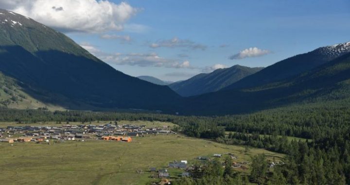
4 min readXin jiang has a vast territory and abundant resources. It is far from the sea, surrounded by high mountains with mountains alternating within basins. The altitude difference is big, and the terrains are complex. There are lofty icy mountains, vast deserts and extensivegrasslands dotted by the oases to form the unique landform structure of”three mountains embracing two basins”Mountains and basins are two basic types of Xinjiang landforms, where mountains account for 55.7% of the total area of Xinjiang and basins 44. 3%. Xinjiang has a distinct landform outline with steep rolling hills and flat broad basins arranging alternately to form the posture of”three mountains and two basins”. The Altai Mountains is in the northernmost of Xinjiang, Tianshan Mountains in the middle of Xinjiang while Karakoram and Kunlun Mountains in the southernmost of Xinjiang. Junggar Basin is between the Altai mountains and Tianshan mountains while tarim basin is between Tianshan Mountains and Kunlun Mountains. The towering of the”three mountains”portrays the expansive regional outlines of the”two basins”, which determines the growth and flow direction of many rivers in Xin jiang and influences the changes in temperature and humidity of various regions in Xinjiang. Xin jiang belongs to the typical inland arid area Due to the strenuous exercise of earth crust. the river undercutting erosion is intense so as to shape the peculiar water scenery in arid areas such as the torrential flow in deep gorgeslakes in plateau, salt marsh in the desert, and the waterfall in steep rocks. There are many beautiful and charming landscapes of arid areas in the three mountains and two basins while glaciers and deserts are the themes of arid area landscapes.

Altai Mountains have a total length of more than 2, 000km, with the part in China stretching from northwest to southeast. The mountains are generally at an altitude of 3,000 meters. The Friendship Peak stretching across Chinese and Russian border is the highest peak of the Altai Mountains with 4, 374m above sea level Tianshan Mountains called Yinshan in ancient times. stretches from east to west with a total length of over 2, 400km and is one of the largest mountain systems in Asia. The Tianshan Mountains in China are all in the territory of Xin jiang of about 1, 700km Ridges and peaks rise one after another, which is imposing. Tianshan mountain range is an important natural geographical boundary in Xinjiang with significant differences between the northern and southern parts in the aspects of climate, hydrology, flora and fauna distribution and the natural landscapes. By tradition, the south of Tianshan Mountains is called”Nanjiang”(Southern Xin jiang) and the north of Tianshan Mountains is called Beijiang”(Northern Xinjiang).

The precipitous and towering Kunlun Mountains surrounded by great peaks encircles the southern edge of Xinjiang. It stretches from the Pamir plateau on the west, connects the Karakoram in the southwest and extends into the western part of Qinghai Province with a total length of 2, 500km. The Pamir plateau on the west has a good reputation of the”the ancestor of mountains”, through which the ancient Silk road passes and leads to Persia(now Iran), etc. It was called”Verdant Mountain”as well as”Vast Kunlun”and “Spinal Column of Asia”in the history of China. The peak group on the Karakoram has an average height of over 5, 500m and the main peak Chogori is 8,611m above sea level and is the world s second highest peak behind Mount Everest.
Junggar Basin is China’s second largest basin with an area of about 380,000km Gurbantunggut Desert in central Junggar Basin is China’s second largest desert with an area of 48.000km².
Tarim Basin is China’s largest fully enclosed inland basin with an area of 530, 000km Taklimakan desert located in central Tarim basin. is china’s largest desert with an area of 337600km”. as well as the world’s second largest mobile desert Tarim River flowing through the interior of Tarim Basin is the longest inland river in China with a length of about 2.100km.
Aydingkol Lake of Turpan Depression in eastern Xinjiang is China’s lowest point onland, 154.3lm below sea level, forming 33 large and small basins surrounded by the mountains.
The unique landform of”three mountains embracing two basins”in Xin jiang gives birth o the diverse and splendid cultures in Xinjiang and shapes the hospitable, kind and great-hearted characters of Xinjiang people. Xinjiang, a land of “gold mountains and treasure basins”, is populated by generations of optimistic and progressive Xinjiang people who love and cherish Xinjiang.


